Jump to: Our Verdict / Features / Specifications
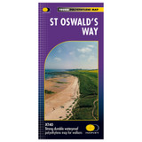
The Trail Map XT40 series are a super light, waterproof set of maps covering some of the most popular long distance walks in the UK at 1:40,000. These are ideal for long distance walkers and section hikers who want a map for simple navigation when covering these long trails.
Harvey Maps says
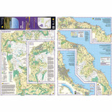
Entire route on one map.
From Holy Island to Heavenfield, the 156km (97 miles) St Oswald's Way links some of the places associated with St Oswald who was the King of Northumbria in the early 7th century.
The route runs through the Northumbria National Park following the stunning Northumberland Coast before heading inland across beautiful countryside to Heavenfield. It links with St Cuthbert's Way in the north and Hadrian's Wall Path in the south.
Along the way you will encounter rolling farmland, villages, vast sandy beaches and fascinating history.
Our Verdict
Harvey Map's Trail Map XT40 - St Oswald's Way is perfect for anyone wanting a practical and durable map to cover large areas without the need for 1:25,000 level detail. The Harvey Maps use light, waterproof paper so they are much easier to use and store than traditional paper or laminated maps. I moved over to Harvey Maps a few years ago and love using them for the weight, slim profile and waterproof nature as they are much more practical to use out on the hill. The Trail Map XT40 series is perfect for long distance routes, whether thru hiking or section hiking these famous routes.
Due to the size of the map and the 1:40,000 scale I wouldn't take this to somewhere new where I would need to do a lot of navigation or straying far from the actual route of this particular walk but for picking out general features or use as a quick reference on your way this is hard to beat. If you haven't used Harvey Maps before they are different to OS maps but key features and symbols are easily understood and you soon get used to them.
- Reviewed by Ultralight Outdoor Gear
Features
- Tough, light, durable and 100% waterproof
- Includes Rights of Way
- Genuine original HARVEY mapping
- Route clearly marked
Specifications
- Weight: 60g
- Scale: 1:40,000
- Ratio: 2.5cm = 1km
- Flat size: 972 x 700mm
- Folded size: 116 x 243mm
- Double sided: No
- Format: Strip map


