A Guide to the Cleveland Way
Posted by Andy Neil on Aug 06, 2024
This is a guide to our local national trail, the Cleveland Way—the first long-distance path I completed and one that will always hold a special place in my heart. This captivating National Trail meanders through North Yorkshire’s diverse landscapes, spanning 109 miles from the charming market town of Helmsley to the picturesque seaside of Filey. Whether you're a seasoned hiker or a casual explorer, the Cleveland Way offers an unforgettable blend of moorland, coastal splendour, and quaint villages that define the beauty of England’s countryside.
In this guide, we’ll take you through the traditional route from Helmsley to Filey, though it’s just as rewarding to hike in the opposite direction. From practical tips on accommodations and resupply points to a deep dive into the trail's rich history and highlights, this guide will help you make the most of your adventure on the Cleveland Way.
Disclaimer: All the information regarding accommodation and resupply points are correct as of July 2024.
Why You Should Hike the Cleveland Way
The Cleveland Way offers diverse scenery, blending enchanting moorlands with breathtaking coastal views, showcasing the best of North Yorkshire's natural beauty. As you traverse this trail, you’ll walk through areas steeped in rich history, encountering ancient abbey ruins and landmarks celebrating famous explorers like Captain Cook. The charming villages along the route, with their welcoming locals, cosy pubs, and delightful B&Bs, provide a taste of traditional English countryside hospitality.
The trail skirts the edges of North York Moors National Park, a haven for diverse wildlife and stunning landscapes. It is accessible and well-maintained, with clear signposts, making navigation straightforward and ensuring a safe journey.
Resupply points are conveniently spaced along the route, allowing you to travel light without sacrificing essentials. The itinerary is flexible, with sections varying in length and difficulty, so you can tailor your hike to suit your pace and experience level. The region's cultural richness is also palpable through historic sites, traditional markets, and regional delicacies, enhancing your hiking experience with profound cultural encounters.
Video Courtesy of National Trails

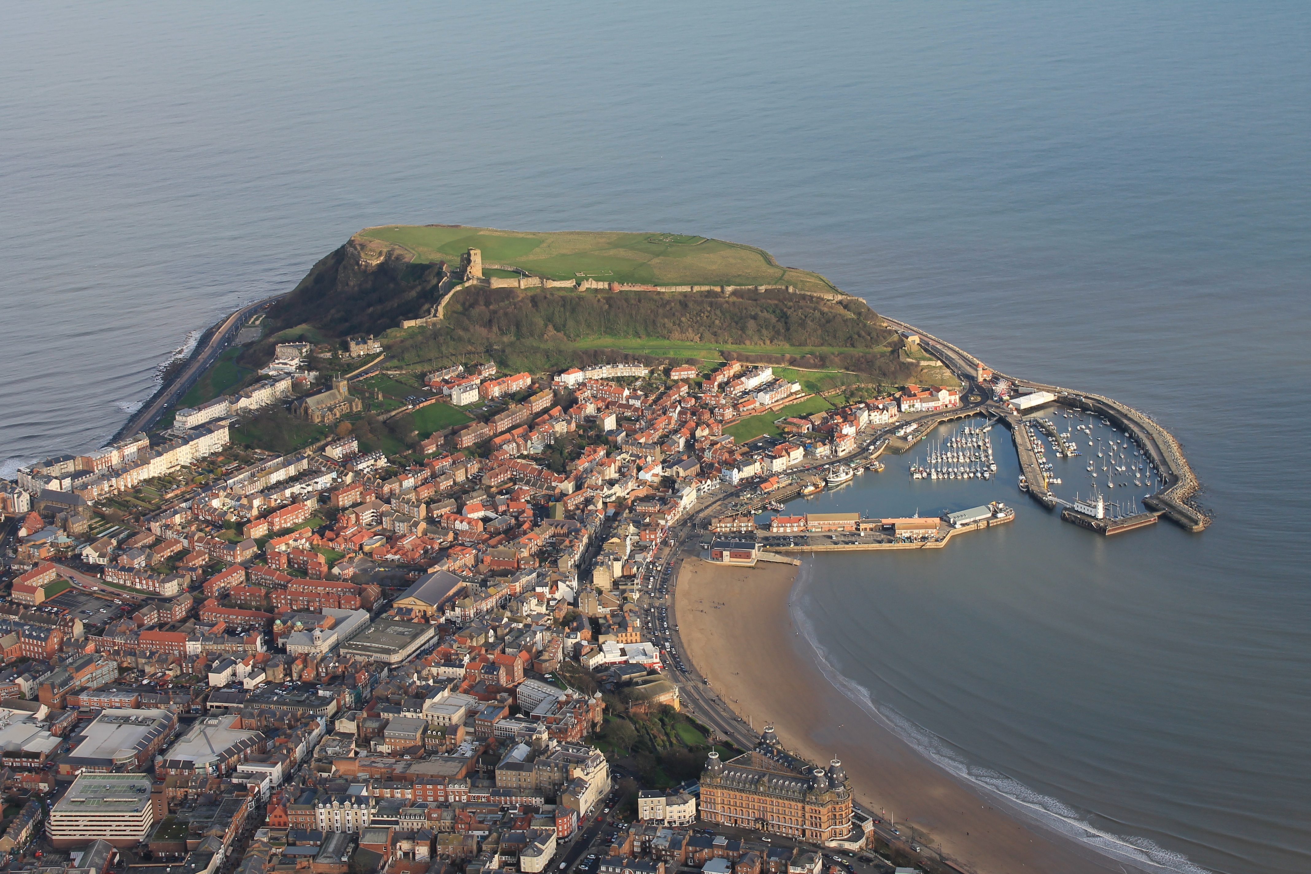
Scarborough Castle Ruins
History of the Cleveland Way
The Cleveland Way's origins date back to 1938 when the Teesside Rambling Club first proposed the idea of a long-distance footpath. However, the onset of World War II and the subsequent post-war recovery delayed the development of such trails. Despite these setbacks, the vision for the Cleveland Way endured.
By the 1950s, serious planning for the trial commenced. The route was carefully crafted to showcase the natural splendour of the North York Moors National Park and the dramatic cliffs and beaches of the Yorkshire coastline.
Officially opened on May 24, 1969, the Cleveland Way quickly became popular among hikers and nature enthusiasts. In recent decades, efforts have been made to maintain and enhance the trail. Conservation projects aim to preserve natural habitats, manage erosion, and improve accessibility. The North York Moors National Park Authority manages the trail with local landowners, volunteers, and conservation organisations, ensuring that the Cleveland Way remains a cherished part of England’s natural heritage.
The Trail Itself
Moorland Expanse
The Cleveland Way can be divided into two distinct sections: the moorland expanse and the coastal stretch. The journey traditionally begins in the historic market town of Helmsley, where the majestic castle and its surrounding gardens provide a grand starting point. From there, the route meanders past the tranquil ruins of Rievaulx Abbey before reaching Sutton Bank. Here, panoramic vistas of the Vale of York offer a breathtaking introduction to the trail. Continuing through the charming town of Osmotherley, the path ascends through the dramatic Cleveland Hills, passing notable landmarks such as Captain Cook’s Monument and the distinctive peak of Roseberry Topping.
Coastal Stretch
As the trail approaches Saltburn by the Sea, it takes a southerly direction, hugging the contours of the dramatic and undulating cliffs. This section of the trail offers a refreshing scenery change, with expansive open sea vistas and breathtaking coastal cliffs. You pass through idyllic fishing villages such as Staithes and Runswick Bay, then to Whitby and its famous Abbey, which sits perched upon the cliff tops. The journey concludes by passing Scarborough Castle, overlooking the final stretch of the trail to Filey, where the coastal vistas offer a fitting end to the adventure.

Staithes, Boulby Cliff: The highest cliff in the East Coast at 203 metres

Saltburn-by-the-Sea: Steps down to the beach

Walking towards Saltburn-by-the-Sea
Challenges and Rewards
While you do not need to be an elite athlete to tackle the Cleveland Way, the trail presents challenges that will test your physical endurance. The Cleveland Hills' steep ascents and descents can be demanding. However, the coastal section is what catches many out. As the path meanders along the seaside cliffs, it often abruptly drops to sea level, only to climb back up onto the cliffs, only to repeat this process, making the coastal stretch arguably more physically challenging than the hills.
Finding Your Way
The Cleveland Way is very well signposted, and staying on the right trail is relatively easy; however, carrying a map is always recommended. The trail is always complemented with a guidebook, which keeps you going in the right direction and helps you immerse yourself in the history and geology of the epic landscape you are walking through. Our recommendations are the Cicerone 'The Cleveland Way and the Yorkshire Wolds Way book' (two trails for the price of one) and Harvey’s 'Trail Map XT40—Cleveland Way'.
Getting To & From the Trail
Getting To (and back to) Helmsley
Public Transport: Helmsley isn't the most accessible for those relying on public transport. The most straightforward option is to get the train to York and then take the M31 bus to Helmsley. Alternatively, head straight for Scarborough and take the 128 bus to Helmsley (you can also use this service to get back to Helmsley once you complete the trail). Another longer-winded Alternative is to get the train to Middlesbrough, take the bus (5, 5A, or the X93) to Guisborough, and then take the M4 Moors bus to Helmsley. A link to the Moors bus route can be found here.
Car: If you wish to drive and leave your vehicle, there are two long-distance car parks in Helmsley, and they will both charge you around £30 to leave your car for 7–10 days; up-to-date prices can be found here.
Getting Back: The most straightforward way to return to Helmsley from Filey is to get a bus or taxi to Scarborough bus station and take the 128 bus to Helmsley.
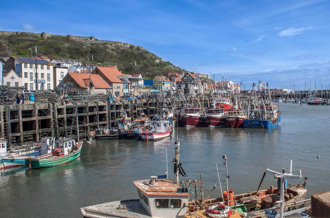
Scarborough Harbour
Scarborough Town
Getting To (and back to) Filey
Public Transport: The most straightforward way to Filey is via train, though it is easier to get to Scarborough. Taking a train to Scarborough and getting a bus to Filey is also an option. As is a Taxi from Scarborough to Filey. A link to the Moors bus route can be found here.
Car: Filey station has a long-stay car park, which costs £8 per week (at the time of writing). Alternatively, park in one of Scarborough's many long-stay car parks, then take the bus, train, or taxi to the trailhead at Filey.
Getting Back: The most straightforward way to return to Filey from Helmsley is to take the 128 bus to Scarborough and then a bus or taxi back to Filey.
When To Hike: The Cleveland Way is accessible year-round, but timing your hike can enhance your experience. Here’s a quick guide to choosing the best time for your journey:

Roseberry Topping, situated near Great Ayton and Newton Under Roseberry
Best Times to Hike
Summer: (June to August) Enjoy the longest daylight hours and generally mild weather, perfect for wild camping. However, be prepared for crowds, especially in Whitby and Scarborough.
Spring: (March to May) and Late Summer (September) These shoulder seasons offer quieter trails and pleasant conditions. Late April to early May and September are ideal for fewer crowds and good weather.
Winter: While the Cleveland Way remains accessible during winter, some campsites, and cafés may not be open. The shorter days and adverse weather conditions, particularly along the coastal stretch, can make the path treacherous. In extreme cases, heavy rainfall can cause the path to become slippery and, in rare instances, even lead to sections of the path collapsing into the sea.
Places to Stay
While not an exhaustive list of every possible accommodation option on the Cleveland Way, this guide provides a solid starting point for planning your itinerary and selecting your preferred lodging locations.
Helmsley: Starting your journey in Helmsley, consider staying at the Helmsley Youth Hostel or one of the many cosy B&Bs in town.
High Paradise Farm: This 16th-century moorland farmhouse offers camping and self-catering accommodations. You don't need to book; just turn up if you plan to camp.
Osmotherley: The Osmotherley Youth Hostel at Cote Ghyll Caravan and Camping Park offers a comfortable stay.
Lordstones Country Park: This picturesque site is high on the Cleveland hilltops and offers camping and glamping.
Beak Hills Farm: a few miles from Lordstones and slightly off the trail, Beak Hill offers a more rustic (but cheaper) option.

Osmotherley

Cleveland Way Sign Post
Camping in Osmotherley

Pier at Saltburn-by-the-Sea
Kildale: Kildale Camping & Barn offers a quiet campsite with basic facilities.
Saltburn-by-the-Sea: Saltburn House offers affordable and comfortable accommodation, while The Spa Hotel provides a more luxurious stay with stunning sea views.
Runswick Bay Caravan & Camping Park: This is more of a “traditional” campsite, but they welcome Cleveland Way walkers, a short walk to a pub for food and a drink.
Whitby: A bustling town with numerous accommodation options, including the YHA Whitby Abbey and various seaside B&Bs.
Robin Hood’s Bay: The Bay Hotel is a popular choice; if you want a bed, the Bay Ness Farm is ideal for campers and just outside town.
Scarborough: Another bustling town with numerous accommodation options.
Filey: As the trail’s endpoint, Filey Brigg Country Park is a good spot for campers.
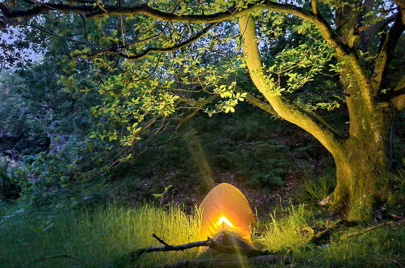
Wild Camping
Wild camping is a viable option, especially the inland section from Helmsley to Saltburn. However, once you join the coastal path, finding suitable spots becomes more challenging due to the increased presence of farmland. Despite this challenge, it is still possible to wild camp along the coastal path if you are responsible and remember to Leave No Trace whenever you do so.
A Warning Regarding Water
Along the trail, water may not be as abundant as hikers are accustomed to. Once you get to the moors, there isn't much water available without substantial rainfall. Even if you have the means to filter and purify water, you may still be thirsty. Once you hit the coast, you frequently pass through villages. Most will have a shop or pub to resupply, but it can be challenging on the moors, especially if you plan wild camping. So consider that you may need more water, especially between Lordstones Country Park and Saltburn, as there is no shop in Kildale.
Resupply Points & Amenities
Resupplying on the Cleveland Way is straightforward, thanks to the numerous villages and towns dotting the trail. Key resupply points include:
Helmsley: (Full resupply) The town has several shops, including a Co-op and local stores where you can stock essentials. There are also various local butchers and pubs.
Osmotherley: Osmotherley has three good pubs, all of which serve food. It also has the quaintest little village shop in North Yorkshire and a small café. If you are looking for a pub meal, I suggest the Golden Lion.
Lordstones Country Park: This is an excellent place to visit, even if you aren't camping. It has a good café for lunch and an adjacent shop where you can stock up on drinks and snacks.
Great Ayton: (Full resupply, off-trail) Supermarkets, pubs, and cafés are available.
Guisborough: (Full resupply, off-trail) This larger town has multiple supermarkets, including Tesco and Sainsbury’s. However, the next stop (which is on the trail) is only a few miles down the road.
Saltburn-by-the-Sea: (Full resupply) Various shops, cafés, and pubs.
Runswick Bay: Coffee shop and pub, but no shop.
Whitby: (Full resupply) A central resupply point with various supermarkets, pubs and outdoor stores. If you are in the mood to treat yourself, get fish and chips from the Magpie café.
Robin Hood's Bay: Small shops and pubs.
Scarborough: (Full resupply) A range of urban amenities. Tesco Extra for comprehensive resupply.

Hutton-le-Hole

Staithes
Points of Interest
Helmsley Castle: This medieval fortress, managed by English Heritage, offers stunning views and a glimpse into the past with its well-preserved ruins.
Rievaulx Abbey: An awe-inspiring site cared for by English Heritage, Rievaulx Abbey features the striking remains of a once-powerful Cistercian monastery set in serene countryside (slightly off-trail).
Sutton Bank National Park Centre & Kilburn White Horse: Sutton Bank provides panoramic views and is home to the Kilburn White Horse, a giant chalk figure carved into the hillside (the white horse is slightly off-trail).
Captain Cook's Monument: This landmark, dedicated to the explorer Captain James Cook, stands on a hill offering magnificent views of the surrounding landscape.
Roseberry Topping: Known for its distinctive peak and rugged beauty, Roseberry Topping is a popular spot for hikers and offers breathtaking views over the North York Moors (an optional climb, but well worth doing).
Whitby Abbey: This dramatic English Heritage site, perched on a cliff overlooking the sea, inspired Bram Stoker’s "Dracula" and provides a fascinating insight into medieval monastic life.
Scarborough Castle: Overlooking Scarborough’s harbour, this English Heritage (get an English Heritage card!) site boasts a rich history and panoramic views from its impressive medieval ruins.
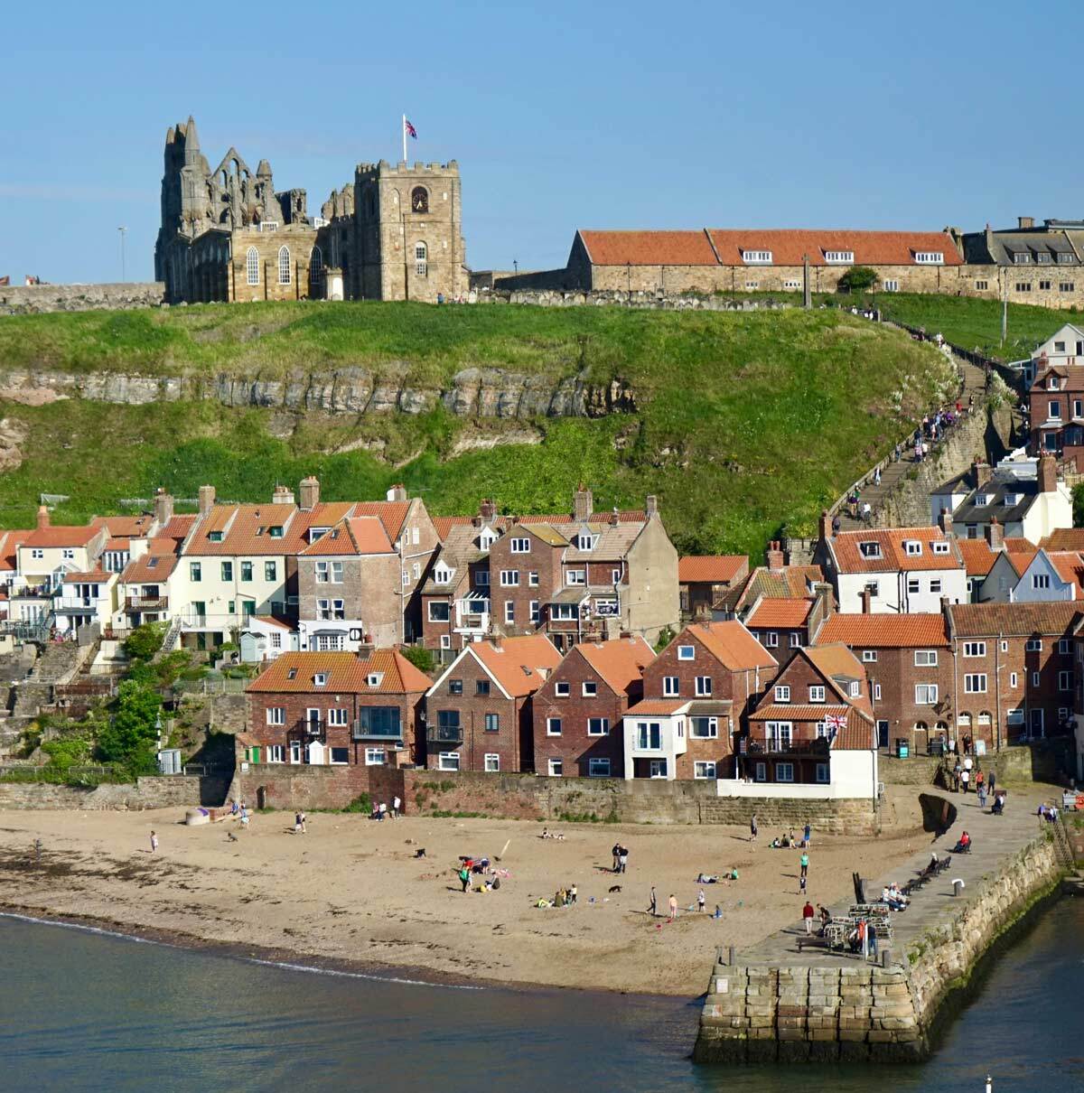
Ruins of Whitby Abbey

Helmsley Castle Ruins
The Yorkshire Wolds Way & Tabular Hills Walk
Two excellent options for those looking to extend their journey beyond the Cleveland Way are the Yorkshire Wolds Way and the Tabular Hills Walk. Each of these trails offers a unique experience and allows you to immerse yourself further in the beautiful landscapes of North Yorkshire.
The Yorkshire Wolds Way
If you have completed the Cleveland Way and are looking to extend your journey, the Yorkshire Wolds Way starts at the terminus of the Cleveland Way. Joining both creates a 188-mile (302km) hike that combines the rugged beauty of the North York Moors with the gentle, rolling landscapes of the Wolds.
Length: 79 miles (127 km)
Duration: Approximately 6-8 days
Description: The Yorkshire Wolds Way is a scenic long-distance trail that traverses the rolling hills and tranquil countryside of the Yorkshire Wolds. The route starts in Hessle, near Hull, and meanders through picturesque villages, farmland, and along the edges of dramatic escarpments. This trail offers a quieter, more serene alternative to the Cleveland Way, with its unique charm and historical points of interest. Notable highlights include the charming village of Thixendale and the ancient burial mounds at the top of the Wolds.

Helmsley Market Town
The Tabular Hills Walk
However, if walking back to the start appeals to you, consider incorporating the Tabular Hills Walk into your Cleveland Way adventure. This rewarding option extends the Cleveland Way into a 157-mile (272-km) circular route back to Helmsley. Embracing this addition allows you to delve deeper into North Yorkshire's diverse landscapes without repeating your steps.
Length: 48 miles (77 km)
Duration: Approximately 4–5 days
Description: The Tabular Hills Walk spans 48 miles and winds through the stunning landscapes of the Howardian Hills Area, offering panoramic views, diverse wildlife, and charming villages. The route features a mix of woodlands, open fields, and dramatic hilltops.
Conclusion
The Cleveland Way stands as a captivating testament to the diverse and breathtaking landscapes of North Yorkshire. With its harmonious blend of moorland beauty, dramatic coastal cliffs, and charming villages, the trail offers an enriching experience for hikers of all levels. From Helmsley's historic market town to Filey's seaside charm, each section of the trail reveals a new facet of this picturesque region.
The trail's well-maintained paths, clear signposts, and abundant resupply points ensure a manageable adventure, while its varying terrain provides challenges and rewards. Whether navigating the rugged Cleveland Hills or traversing the undulating coastal cliffs, the Cleveland Way invites you to immerse yourself in a landscape rich with natural beauty and historical significance.
For those looking to extend their journey, the nearby Yorkshire Wolds Way and the Tabular Hills Walk offer additional opportunities to explore North Yorkshire’s diverse terrain. Each extension promises its own unique experiences, from the serene rolling hills of the Wolds to the expansive, circular routes of the Howardian Hills.
In conclusion, the Cleveland Way is more than just a hike; it’s an opportunity to connect with the heart of North Yorkshire, walk through history, and witness the stunning landscape. Whether you are a seasoned trekker or a curious newcomer, this trail offers a memorable adventure that will linger long after your journey ends. Happy hiking!

|
||
 |
||
|
Andy Neil |
||
|
Andy has been a keen long-distance hiker and wild camping enthusiast since he completed the Cleveland Way in 2015. Since then, he has walked thousands of trail miles all over the UK and is an active member of the Wild Camping UK community, being an admin of the largest wild camping community on Facebook. He strongly advocates for responsible wild camping and believes it is important to leave no trace when camping in the wilderness. He joined the UOG team in 2021 and works as a website developer and content creator. |
||
This is a guide to our local national trail, the Cleveland Way—the first long-distance path I completed and one that will always hold a special place in my heart. This captivating National Trail meanders through North Yorkshire’s diverse landscapes, spanning 109 miles from the charming market town of Helmsley to the picturesque seaside of Filey. Whether you're a seasoned hiker or a casual explorer, the Cleveland Way offers an unforgettable blend of moorland, coastal splendour, and quaint villages that define the beauty of England’s countryside.