Glen Shiel Round and the Five Sisters of Kintail - 2022
Posted by Mark Richardson on Oct 19, 2022
I was contemplating a late season excursion and Scotland was beckoning, a high-level backpacking route would most likely avoid the tail end of midge season and I could extend my Munro tally before the poor autumn weather kicked in.
It was settled then – I headed up to Morvich campsite near Shiel Bridge taking most of the day to get there, the campsite’s nice and only a short walk to the Kintail Lodge for a pie and a pint. Minimal midges so I’d got that right.
My route was to ascend to the ridge via the path starting at the hamlet of Ault a chruinn, following the course of the stream to eventually gain the ridge between Sgurr na Moraich and Beinn Bhuide, strictly speaking this wasn’t the start of the ridge but it is the recognised way up.
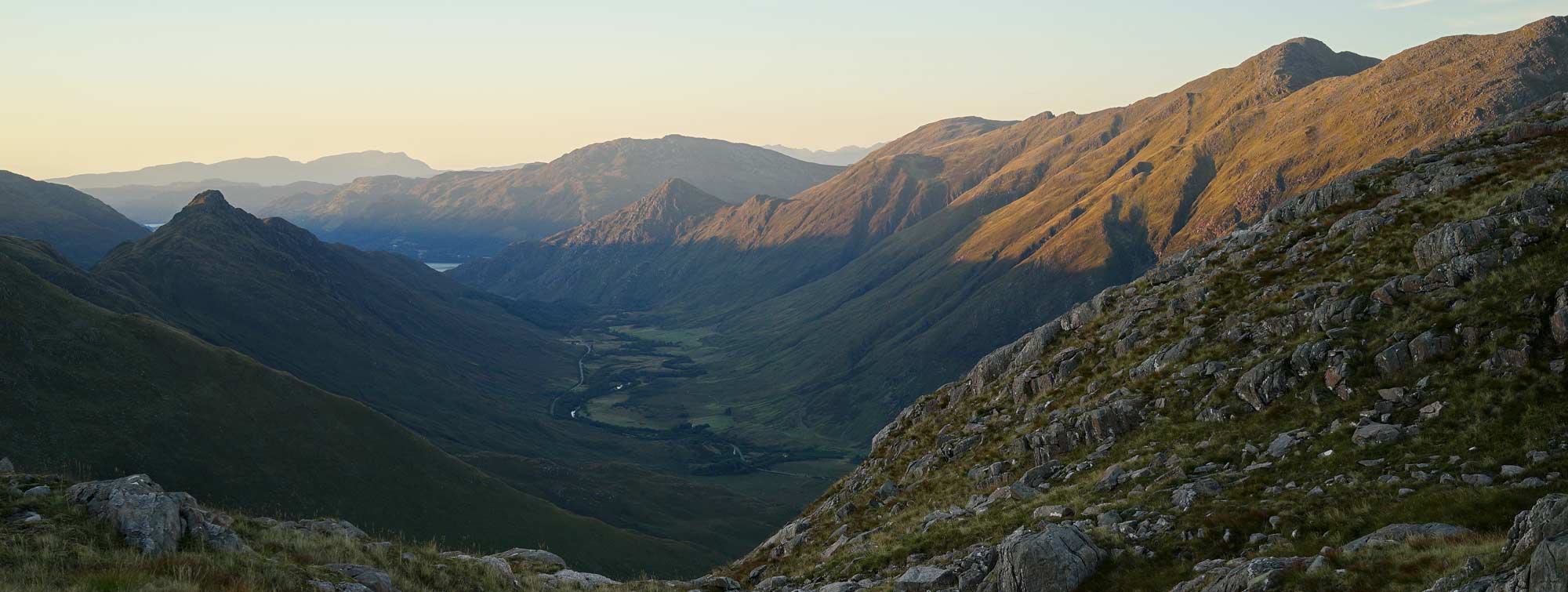
I would then walk the full length of the Northern side of Glen Shiel, taking in the Five Sisters of Kintail and six Munros in total and camping one night along the way. At the end of the ridge, I’d drop down to the Cluanie Inn and ascend the Southern side to complete the circuit back to Shiel Bridge and taking in another nine Munros and involving two further nights camping as high as possible.
It was a route full of promise and didn’t disappoint.
Day 1
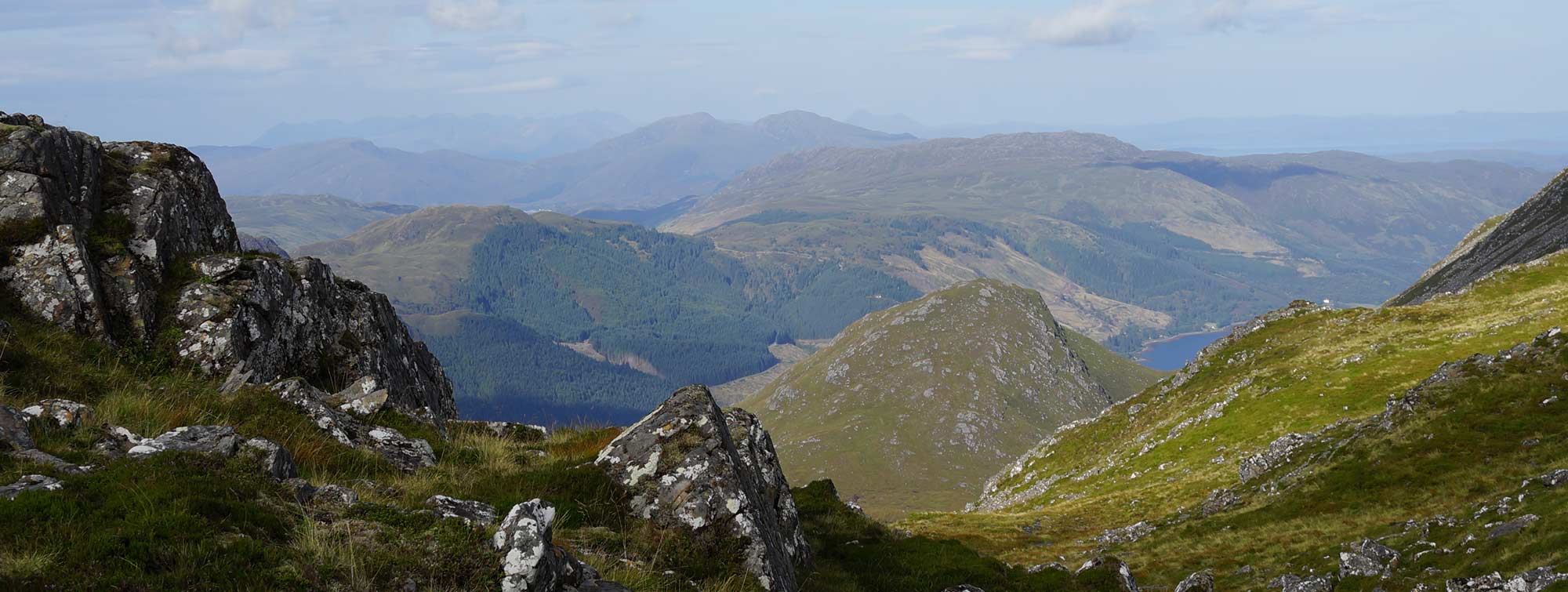
There’s a place to park in Ault a chruinn specifically for walkers so I parked the car and set off to find the path, not straightforward as it starts as a road serving three or four houses then peters out into a track beyond. The ascent to the ridge is steep in places but straightforward, I gained the small saddle after two hours. There were views in either direction from here but looking along my route up the ridge the going was steep and swathed in cloud.
Having spent a full five days earlier this year summiting Munros in mist I was getting a bit tense about this trip, living in England means a trip to Scotland is a significant investment in time and you can’t just pick and choose the good weather days.
I headed off and was soon enveloped by clouds but doggedly followed the path to the summit of Sgurr Fhuaran which I reached at 11.50, that’s 4 hours from the start. The wind had gotten up and there were no views. I should point out I’m the wrong side of sixty so the timings will be pretty slow – over the years when following guidebook trails, I was always comfortably under the estimated times, then there was a period when the timings were spot on, but laterally I tend to lag the estimates, much to my disappointment, I’ve yet to come to terms with old age.
At 977163, which is the col between the first 2 Munros, you could actually camp here even drop lower where there is a stream, need to filter water of course. If you drop down to the stream there’s a bit more shelter.
I reached the second Munro, Sgurr na Carnach at 12.50 after a bit of a scramble, still, no visibility save for the occasional break in the clouds revealing the valley below.
I pressed on dropping down slightly before the ascent to the next Munro where I stopped for lunch, I chomped my cheese and crackers in the mist, though I managed to find a spot out of the wind. After twenty minutes or so I left and climbed to the summit of Sgurr na Ciste Duibhe. This concluded the first three Munros which are quite close to each other, the next one, Saileag was a trek but I was hoping to reach it and camp beyond.
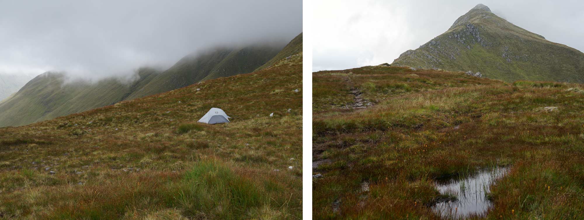
I reached the saddle at 010145, 725m, just before the ascent to Saileag. I’d been walking for 8 hours by this time, feeling knackered I decided to camp before tackling the next Munro. The problem was water – there were some small pools on the saddle itself but they were pretty brackish, I dropped off the left-hand side of the ridge to see if I could pick up any better quality water, I spent half an hour but couldn’t find a better source than the pools on the ridge so I climbed back up and decided to use one of them.
I had a small bottle with me so I could scoop up water from shallow pools, I filtered it and made a meal. Weather was still misty and windy, there were no views. I managed to pitch the tent on a moderately flat area but the pickings were thin.
Day 2
I reached the top of Saileag at 8.30 having left camp at 8 am. Windy and no views.
An hour further from where I’d camped, at 02581450, there’s another saddle and a big pool of water just off the ridge where you could easily drop down and camp, better than the place I had stayed, more sheltered. If this pool is dry then there’s also water further down, although quite a drop from the ridge it would be an easy slope to regain the ridge the following morning.
The next Munro caused me some issues, remember there was no visibility, I carried on the path until I reached the rocky summit of Sgurr a Bhealaich Dheirg, it’s a tall rocky sentinel perched on the ridge and it was easy enough to find. Carrying on from here was problematical though, I couldn’t find the way off, and the only path was in the wrong direction, I followed it to see if it would change direction but it stubbornly refused to change. I followed a bearing but it was very steep and unlikely. Returning to the summit I got the guidebook out, something I should have done earlier, it explained the summit is off the main ridge and you have to retrace your steps, I did this and found the spot where the summit path met the main ridge – I hadn’t noticed the fork on the way up, with good visibility it would all have been so obvious. I’d lost about half an hour.
Noted a possible camping site at 0401386, there’s a small pool and you could get 2 tents on it.
Quite a few tents could camp at 04641369 – there’s one pool of water that would need filtering.
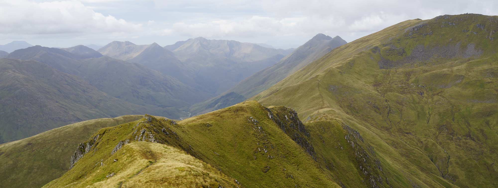
Finally, the cloud cleared on the next section and I could see the ridge behind me, including the routes off Sgurr a Bhealaich Dheirg that I’d flirted with. Reached the summit of Aonach Meadhoin at 12.05 and stopped for lunch, finally got a cloud free Munro summit – most others are cloud free too now.
The Munro guide I was using suggests doing Ciste Dhubh as an offshoot on the descent from Aonach Mheadhoin but I didn’t have the scope for this time or energy wise and decided to follow the ridge to its true end and descend down the front. This is perfectly possible if you keep to the right of a craggy bit below the last summit cairn. There was apath initially but it disappeared fairly fast. The decent took longer than I thought and I didn’t get to the Cluanie Inn until 2.30pm. I bought a pint for £6 and sat outside looking back at my descent route.
The next section is an easy and level walk along an estate track but it took a full two hours, its across marshland and I didn’t see a single place to camp along its route – I decided I would start up the ridge and find some flat ground on the way up, I could see a shoulder not far up which was one spot at least. I turned off the track at 5pm, and gathered about 3.5Litres of water which would give me the flexibility to camp on a nice spot even if there wasn’t any water nearby.
The sky was pretty clear now and it wasn’t long before I found a magnificent camping platform with a great view down the glen to a distant loch (09860696). The aggravations of zero visibility and a windy night on the Kintail ridge melted away as I had a meal, relaxed and looked for a good spot to watch the sunset.
Day 3
Day three dawned wonderfully, the skies were not quite clear but the clouds were high and the mountains majestic. I lingered a bit over getting ready to leave but left my campsite at twenty past eight.
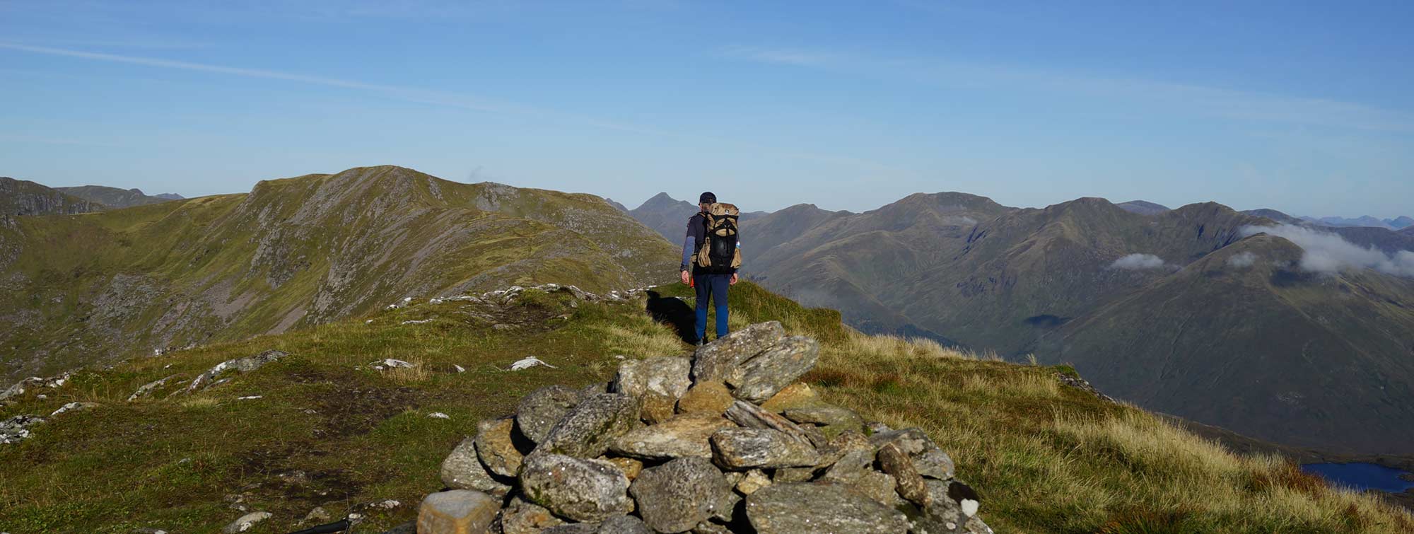
I arrived at the first Munro, Creag a Mhiam an hour later, slightly behind the guidebook time, hardly a cloud in the sky above now, I could see the ridge stretching out ahead of me. It took just another 30mins to skip across to Druim Shionnach which has an interesting scramble to get to the summit. A smattering of roving mist spoiled the views.
In contrast to the northern ridge, this southern side of Glen Shiel has a broader ridge in most places and therefore has any number of wild camping spots near large pools of water, though they might be difficult to find in poor visibility simply because of the expanse of the ridge. I passed through Aonach air Chrith and arrived at the Mal Chin Dearg summit at noon, I was really enjoying the trek and was feeling strong so I continued.
Hunger took over not long after and I stopped for lunch before the climb to the next Munro at 12.40.
The southern ridge is covered by the Cicerone guide to climbing the Munros and suggests taking either one or two days to cover the ridge from Creag a Mhaim through to Creag nan Damn before descending back to Glen Shiel, however, there are two more Munros further along the ridge that looked like they could be linked to the ridge by wild camping another night.
The path was brilliant, as was the weather, earlier mists had cleared and the views were spectacular, it was a perfect day for hiking a ridge path. At a couple of points, the main path diverts from peaks that aren’t Munros and skirts them to save time and effort, as I was doing the ridge I stayed on it rather than taking the easy paths.
I reached Creag nan Damn at 15.40, the final Munro in the guide, the path continues onward anyway before turning downhill towards the glen so I continued along the path until just before the junction where a nice camp spot presented itself at 971114. It was 4.30 pm and I reckoned I’d gone far enough that day – there was water, a fantastic view and the promise of a warm sunset.
There were a few midges about later in the evening which probably means this is not a good spot to camp in the summer, I put on my mossy headnet but then decided there weren’t enough of them to bother me much.
I studied the map as the link I was proposing to do to reach Sgurr na Sgine was not covered by the guide, and there wasn’t a path marked on my map, however, looking at the contour lines and the craggy bits marked on the map I could see a likely route to it.
Day 4
Day four dawned as Day 3 had done – a great morning, and as this was the last day, I was keen to get an early start, I was packed and away by 7 am and on the summit of the first peak Sgurr aBhac Chaolais (not a Munro) at 7.40. Luckily there was a path to follow traced by a line of old iron fence posts. The path disappeared on the summit but the fence posts remained.
I followed the line down the other side to gain the saddle beneath the cliffs of my next objective, Sgurr na Signe. Quite quickly the ground became steep and rocky and the fence posts no longer seemed to be the best route. I picked my way down the steep face fairly convinced I was following in someone’s footsteps judging by flattened steps between the rocky moves. I was on a down scramble at times.
Eventually, I reached the top of a boulder slope which I awkwardly negotiated down to the saddle. Later I could look back at the full bulk of Sgurr aBhac Chaolais and could see that there weren’t really any other options to descend. Perhaps the reason why linking Sgurr na Sgine to Creag nan Damn is not suggested anywhere.
Ahead was a pretty impregnable cliff face but I was planning to contour to the left and gain a ridge line which would take me to the summit. The map showed it to be a broad slope on the other side. A wall was co-incident with the route I wanted to take so I followed it until it plateaued out and began to drop (944110) – then I turned 90degrees to the right and climbed onto the ridge.
It was as predicted and a relatively easy climb to the summit of Sgurr na Sgine which I reached at 9.10 am, it was quite windy but clear. I was back on the guidebook route.
I followed the standard route to The Saddle (the next Munro) passing a few good camping spots before the last climb up to it, which has a very steep section at the end of it. Climbing The Saddle this way misses the standard route up which takes in the Forcan Ridge, which is a bit of an airy scramble and worth the effort.
The Saddle is the last Munro on the ridge but the ridge continues West and then North West on a fairly spectacular path which was the one I intended to take. Other options would be to descend via the path that Munro baggers normally come up on – this could include a descent of the Forcan Ridge or that can be skirted altogether. Another option could be to retrace steps back towards Sgurr na Sgine and picking up the normal descent route from there.
Both these options would leave me with a long-ish road walk along the glen to Shiel Bridge and Ault a Chruinn so continuing along the ridge was best for me. There’s a great path which sticks close to the cliff edge most of the way and is a fine route. There are two peaks passed, Spidean Dhomhnuill Bhric and Sgurr Leac nan Each after which the mountain broadens out and the path peters out.
The route North along the broad ridge is tough. Although not clear from the map it is very uneven and you are continually climbing up and down its undulations. Ultimately I wanted to be in the valley to the right hand side, but descending too early is not possible because its too steep and rocky, however where possible I moved to the right hand side so I could see the possibilities. At 918144 I spotted the start of a route down to the valley floor, I decided to give it a try, it was almost 1pm.
In fact the path took me down so far then disappeared, as I was now in the valley though I contoured rather than headed for the bottom because I could see the terrain near to the river was rougher than where I was. Eventually I worked my way down the valley and closer to the stream at its lowest point, I then picked up a path heading down, (marked on the map) which increased my progress somewhat and eventually joined a more substantial path that would take me to the campsite by the side of the road at Shiel Bridge. I reached the road just after 3pm and walked the 1 and a half miles along the road back to the car.
It’s a great route that could probably be done in 3days by fitter backpackers.

|
||
 |
||
|
Mark Richardson |
||
|
Mark was the founder of Ultralight Outdoor Gear back in 2006 and has completed long distance backpacking routes in some of the remotest parts of the world. His favourite hikes have been Torres del Paine (full circuit), the John Muir trail and the Markha Valley trail (Ladakh, India). Although semi-retired Mark has not lost any enthusiasm for minimalist backpacking and is tackling Scotland’s Munros choosing multi-day backpacking routes over the more usual guide book excursions. |
||