Ladakh 2016 - Trip Report - Trek 2 Lamayuru to Chilling
Posted by Mark Richardson on Sep 01, 2016
Day 1 - Lamayuru (3491) to Phanjilla (3230m)
Breakfast at 7.45 was followed by a taxi at 8.30, the hotel owner had booked the transport for us to Lamayuru and had booked the pickup from Chilling five days later, rather than a regular taxi the people carrier was liveried with a trekking company logo so they were likely to be used to the kind of ride and pickup we needed. We tried to converse with our driver but it wasn't easy, he seemed to understand when we were re-iterating the pickup point and time. After 2 and a half hours we were dropped off at Lamayuru on the roadside below the main village.
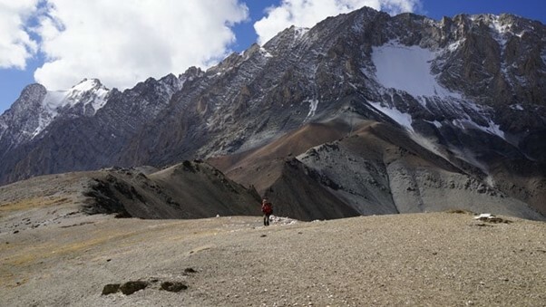
We walked back down the road and cut across the valley to some chortens which marked the route, it was straightforward to follow the path beyond into a side valley where the path winds its way eastward gaining height all the way. Most of the route is in a narrow gully but after a while it opened out and we could see the Prinkiti La pass, the path skirts the left hand side of the valley until you enter the narrow cleft which is the pass itself.

A good view of the Zanskar range presents itself from the top. The route from the pass descends steeply into a very narrow gully which you can straddle with your hands in places and which required a scrambling descent for some sections - it was a good route, although Geoff was not feeling well. Eventually the gully opens into a larger one with a dirt track which is followed to Shilla Village. We continued on for another km to reach Wanlah, the biggest village in the area, connected to the outside world with tarmac roads.
Wanlah is quite depressed and the campsite uninviting, we continued down the road for a further couple of hours until we reached Phanjilla at 4pm - the approach to which is dominated by jagged and colourful mountains at the head of the valley. The campsite was closed but we used it anyway - although it was difficult to find a completely flat pitch, we ended up near to a steep drop off to the river, but its a nice site and we were very comfortable.

Day 2 - Phanjilla (3230m) to the Yak Herders encampment below Konze La (4300m)
Set off today at 7.40am, the route to the next town, Hinju, was supposed to be on a track according to the guide, but now its a tarmac road and we followed it, climbing all the way to Hinju. We walked through the village to the campsite on the other side and stopped for lunch at about 11.00am. Hinju is at 3750m and the altitude seemed to be affecting me, I was slowing down again, lagging behind Geoff.
Beyond the campsite the route continues climbing and we intended getting as close to the Knoze La as we could in order to give us the best chance the following day. Eventually we could see the steep trail from the pass - a few horses had just come over it and were kicking up major amounts of dust meaning we could follow their progress easily - it looked a daunting climb and I was sure I was going to make it - but I kept that detail to myself.
When we reached the Yak Herders encampment we decided to camp - it was only about 2.30pm but we didn't think we could get over the pass and weren't certain there were any campsites closer to it. We relaxed, had a meal about 5pm and went to bed as it got dark.
Day 3 - Yak Herders encampment below Konze La (4300m) to the Chilling/Alchi path junction (3800m)
After porridge and coffee we packed up and were away by 7.30am, there was a km or two walk in the valley before the route started climbing the left side, threading through a rocky cleft. I was feeling stronger today and managed to keep a steady pace up the switch-backed route, as we got higher you could see more of the valley behind us, spectacular views. After a couple of hours we reached the Konze La pass (4900m) and gazed at the magnificent view on the other side - the valley ahead stretched out into the distance flanked by muti-coloured peaks the view was amazing. We spent a long time here, soaking up the atmosphere and taking a huge number of pictures.
We spent about thirty minutes on the saddle before starting our descent, initially down the centre of the valley then looping down the left hand side eventually reaching the valley floor as the path met the river, the first water we had encountered since leaving camp that morning. There were two other trekkers at the river, two American hikers we had seen on the Markha Valley Trek, they were doing the route from Sumdo La to Alchi.

We continued down the valley to a little village, which looked decidedly down at heel, even by Ladahki standards. A short while after reaching the village we had lunch, at a river crossing, Geoff stuck his feet in the river causing the some fish to jump onto the bank flapping for air. We moved on after lunch but were feeling tired and lacking energy, further on the path rose up the right hand side of the valley and evenutally arrived at a grassy area flanking a side stream.
It was an idylic spot, used as a campsite during the busier part of the season, we lay in the sun for the next hour, and would still be there if a cloud hadn't covered the sun momentarily.

We passed through Sumdo Chinmu and carried on a few hundred feet above the valley floor to a path junction just before the next climb where we had decided to camp. On our side of the river there was a ruined building adjacent to a small flat area where we could camp, but it was enclosed and not very appealing, Geoff hopped over the river for a look on the other side and found a much better site which was clearly the place everyone would use, it wasd eserted so we pitched our tents and set about relaxing.
I was filtering water in the stream when a Danish girl turned up from the Alchi direction - Christina was on her very first camping trip and it showed, she had little hot food, was carrying about three times the amount of gas she needed and had managed to get her sleeping bag wet. She talked to us until dark, around 7pm when we went to bed.
At 7.30 a team of horses came into the camp with a handler - there were no clients and little cargo, he was on the return journey from taking clients to Chilling - he setup camp in the dark, started a fire and made bread. By the time we got up the following morning he was gone, and I didn't hear a thing.
Day 4 - Chilling/Alchi path junction (3800m) to the Gorge above Chilling
We burned rubbish in the pre-prepared fire pit before setting out at around 8.00am, at the back of the camping place a switchback path climbed steeply up the side of the mountain but after consulting the map and guidebook it seemed there was an alternative path farther down the valley which seemed to be more gradual (from the map) so we decided to head for it. It was further than we thought, we hiked along the left bank until we hit our marker, a footbridge, after twenty minutes, crossing this we found the start of the path we were looking for and a french girl popped out of the undergrowth. She was ahead of her companions but all three were looking for the same path we were, they soon caught up and we set off through the shrubs.

The map shows both paths starting from the same point in the valley but this is not the case and when we started to struggle to find our way the french girls asked us about the other path - we told them it was about a twenty minute trek back. I was pretty close to following them because the undergrowth was very difficult to penetrate and it didn't seem possible that the path was here - not for the first time Geoff found the correct path, he had been checking out the other side of the gully and discovered the path climbing out of the immediate entanglement - we followed it.
The path snaked up the narrow valley in and out of bushes and small trees and was not well defined at all, it cannot have been well traveled either because we had to push our way through the vegetation.
Eventually we came to a steep section of crumbling rock which we had to negotiate on its left hand side - the loose rock and fine sand covering everything made it very dicey with the potential to fall 15-20 feet. We had obviously strayed off the path but it was difficult to see where, luckily we were near the top of the gorge and therefore we were able to strike up the hill and out onto open countryside, although this also involved a steep and slippery ascent up a slope.
Once on relatively level ground again we could see a path coming in from high on the left - this was obviously the original path that started just behind our campsite - we also found a continuation of our path from the gorge, which led to a shredded, abandoned tea tent protected by a low wall. Presently our path and the original one joined each other and we followed two hikers who had entered the plateau on the original path, to a group of stone buildings and a campsite - we sat down for a long rest.

We could see the original path and where it turned onto our plateau in the distance, a figure appeared on it which we watched for ages as they hiked towards us eventually realising it was the leader of the french girls. When she arrived she thanked us for getting them on their path, we said she'd made the right decision given our experience.
After a while one of her friends arrived and explained that the third girl had turned back and was making her way to the nearest road and was intending getting a lift to Chilling. So there were six of us heading up to the next pass, Dung Dung La (4710m). Geoff was feeling quite rough, I felt OK and was able to maintain a steady pace but this meant I got way ahead. All our other companions however passed both of us easily and hiked to the pass well ahead of us. Eventually I gained the pass and had some lunch, it was full 30minutes before Geoff arrived, he had run out of energy, he thought it was lack of food.
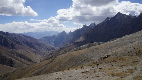
The views from the pass are good - but as we started our descent the change in viewing point improved the view dramatically - we had some of the best views of the whole trip, as this was our last pass it was a fitting finale and we were suddenly feeling very good. We'd had no water since the campsite on the plateau and supplies were running low, the guidebook said 4 hours from the pass to Chilling, but perhaps just 2 hours to the next water - the descent route is gradual on rolling hills until it hits a narrow valley and it was here we expected to find the next water source.
It was hot and the descent seemed to take a long time - finally the entrance to the gully came into view, we were both now out of water completely - on the approach there was a run of water over a large boulder section, it was not enough to take anything useful from but we knew there'd be water in the gully when we reached it. But there wasn't - the gully was dry and the smear of running water we'd passed over was not too far behind us to reach again, it looked like we might have to go all the way to Chilling tonight - that would mean arriving as darkness fell.
Resigned to this we plodded on making the best time we could down the gully, criss crossing the river. After a further 30 minutes (at 4.30pm) our gully joined a much large one coming in from the right - it had a healthy river in the bottom and a clear camping spot by the side of the path, we were relieved and delighted. We camped immediately and I set about re-hydrating. Geoff was complaining that he still wasn't feeling well but he was not drinking - I talked him into drinking some water and kept at it as we both rested then prepared a meal using the last of our food.

Day 5 - Gorge above Chilling to Chilling
Had a leisurely morning and were ready to go about 8.30am, it took an hour to walk down into Chilling, where we saw the three french girls in the garden of a homestay, we exchanged plans, they were splitting up with one going to hitch hike along the road and the other two heading in the opposite direction towards Skyu - a village we had passed through on our first walk two weeks earlier.
Our taxi was booked for 1pm out of Chilling but we were told that the road was often closed because of rebuilding work, hence we decided to walk along the road until we got beyond any potential closures - there was only one road to Chilling and therefore we would not miss our lift coming the other way.
We walked all the way to Sumdo Da and as it was approaching midday we decided to wait - we had obviously passed the roadworks so there was no danger of our lift being unable to get through - our taxi turned up at 12.40pm.

|
||
 |
||
|
Mark Richardson |
||
|
Mark was the founder of Ultralight Outdoor Gear back in 2006 and has completed long distance backpacking routes in some of the remotest parts of the world. His favourite hikes have been Torres del Paine (full circuit), the John Muir trail and the Markha Valley trail (Ladakh, India). Although semi-retired Mark has not lost any enthusiasm for minimalist backpacking and is tackling Scotland’s Munros choosing multi-day backpacking routes over the more usual guide book excursions. |
||
