Knoydart 2017 - Trip Report
Posted by Danny Pearson on Mar 01, 2017
Day One
Up bright and early to get the 300 mile drive to Glenfinnan completed with the intention of setting off late afternoon. As we travelled north towards the highlands the clouds cleared to be replaced with stunning azure skies. As we sat on the banks of Loch Lomond eating lunch, we couldn’t quite believe how warm it was, it felt like a perfect summers day. Everything had been packed including 5 days worth of food (enough to allow for cold weather and the longest potential).
Swift progress was made on the surprisingly quiet roads and we were at Glenfinnan by 2.30pm. We decided to leave the car at the Glenfinnan House hotel car park (I hope they don’t mind). The hotel sits in a wonderful peaceful setting and inside has a charming cosy feel, we didn’t stay but it looked very nice.
As we set off up the leafy driveway we spotted what I thought must be a statue of a deer. Surely there wouldn’t be a large stag nonchalantly munching on someone’s flower bed as we walked past. When he turned to look at us it was quite clear that this 10 point stag was very real indeed! We left Glenfinnan, passing under the Harry potter viaduct, feeling incredibly lucky with the weather. When the trip was planned, I certainly was not expecting to be wearing a light base layer with the sleeves rolled up in the Highlands in March! The first few miles follow the tarmac estate road running alongside the River Finnan. The plan was to head for Corryhully Bothy and depending on the time either stop here for a night or press on further up the valley. We got to the bothy at around 4.30pm and there was still plenty of light so we decided to carry on and wild camp by the side of the River Finnan. After couple of miles we found a perfect pitch on the bank of the river.
After pitching the tent we were soon chilling by the river with steaming cups of tea. Food for tonight was sandwiches washed down with cuppa soups. We watched a couple of people descending the steep sides of the Munro, Sgurr Thuilm which towered above us as we ate. As they neared the bottom of the slope, about a 100m from us, one of them lost their footing and tumbled head over heels down the hillside. Fortunately, she was lucky and apart from some grazes and bruising was intact. It did serve as a reminder that once in the wilderness you are miles from help if things go wrong. At dusk as the sun fell several stags that seemed oblivious to our presence and wandered past us on the opposite bank. It was awesome to have these grand creatures passing so close to our camp. We had every intention of staying up to look out for the Aurora Borealis but tired after the long drive we fell asleep.

Glenfinnan Stag

Leaving Glenfinnan Estate
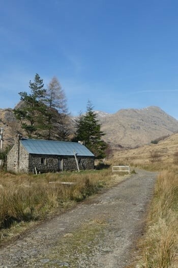
Corryhully Bothy

Setting up camp
Day Two
Usually when sleeping in a tent I wake early with the sunrise so hadn’t bothered to set an alarm. It was 8.15am when I stirred, we’d slept in! Not quite the early start that I expected. There was a light frost when we woke, even waking that late.
Today we would be climbing over to Strathan and into Glendessarry. The route to the Bealach a’Chaorainn started on a double track which gradually disappeared until we were picking our own route up the valley. The climb got progressively steep and boggy with Sgurr Thuilm and Streap looming over us. We scrambled up the rocks and bogs made harder with the weight of the packs. At the top, the valley opens out with a large cairn marking the boundary between the Glenfinnan and Glendessarry estates. A metal gate stood alone, the accompanying fence long since gone, with a sign ‘Please Close the Gate’ still in place.
There were still areas of snow remaining and the melt water was making getting across the streams tricky in places and the surrounding ground was increasingly boggy. I was extremely glad of the trekking poles when trying to negotiate steep rock steps along the edge of Allt ‘A Chaorainn. The path clung mostly to the northerly side of the river and was steep and slippery. I twisted my knee when a section of snow gave way whilst making our way down, it was pretty uncomfortable but I was sure that it would ease. There were several river crossings, and on one such crossing, I had taken my hands out of the pole loops. This was followed by a comedy slip finishing with a pole disappearing off down the rapids. After clambering down a steep bank, followed by some balletic hopping from rock to rock, I retrieved my trusty pole! Despite getting almost knee deep during a few river crossings, the gaiters were a godsend (the water didn’t reach the top). At our lunch stop we reviewed our progress. The combination of rocky ground, bogs and river crossings had resulted in us only covering around 1 mile per hour!
Research before the trip suggested crossing the Allt A’Chaorainn some distance before it joined the River Pean as the crossing near the bridge over the Pean could be tricky. We crossed about a mile upstream without any problems and climbed the hillside to join a ghillie’s quad bike track. Looking across to the path marked on the map on the opposite bank we’d definitely chosen well. Sections of the path had collapsed into the river in places leaving loose scrambles which would have been tricky with loaded packs.
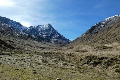
Streap

Descent from A'Chaorainn

Almost through the Bealach
After slogging along the extremely wet and boggy track we eventually reached the River Pean and the entrance to Glendessarry Forest. Progress had been disappointingly slow having taken 6 hours to cover 6 miles due to the difficult terrain and ground conditions. We topped up our water bottles from the Pean using a water filter and sat on the log bridge and enjoyed the view. Once over the bridge the track became wet and muddy as it entered the Forest. After a few hundred metres we were relieved to reach a hard packed forest track. At last we made swift progress through the forest on this smooth surface heading for our digs for the night at A’Chuil bothy.
We had heard that the forest had a population of wild boar so we were on the lookout for a sighting of them. We didn’t see any but did pass some enclosures with trap entrances which must be used by the estate to capture them. What we did see plenty of was Pine Marten and Scottish Wildcat tracks and scat. Both animals must use the forest tracks as a means of getting around from the number of tracks following the same route that we were taking. We didn’t actually see any but there must be a healthy population from the amount of prints and poop. We also passed several hides which at first we thought must be spotting wildlife but eventually deduced were for shooting boar. Each hide was in sight of an open area with a plastic barrel on a chain covered in holes. They must fill the container with food to attract the boar and then shoot them from the hides. There were ranging poles situated near to each feeding area. Not really very sporting in my opinion but I’m sure people pay vast sums for the privilege.
By the time that we arrived at A’Chuil Bothy at around 6pm I was struggling with my knee which I had twisted earlier in the day. It was a relief to be able to sit down with a cup of tea knowing that was it for the day. We cut some logs from a fallen tree and then sat watching around 30 deer moving around the open marshland below us. Dinner was more freeze dried fare, after which we got the fire going in the bothy and headed inside. The fire was a great opportunity to get our socks dried but unfortunately a combination of damp wood and a poorly drawing chimney meant that the fire only lasted a couple of hours but it was great while it lasted. It had been an exhausting but enjoyable day which we ended with some star gazing. The lack of any light pollution was perfect for looking at the stars.

Bridge over the Pean

A'Chuil Bothy
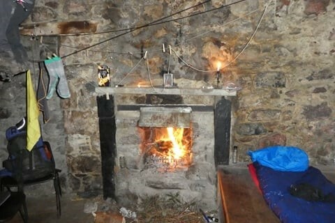
Fire in A'Chuil
Day Three
The bothy felt very cold and damp when we woke, probably due to its somewhat shaded location on a north facing hillside. A slight mist and low cloud was initially hiding the peaks of the Munros across the valley – Sgurr Na Ciche, Garbh Chioch Mhor and Sgurr nan Coireachan. What a view though as the cloud lifted and the sunshine bathed the mountain sides. It looked set for another day of amazing weather with clear skies all around us. Within moments of setting off we met more deer on the track. By this time we were getting a little blasé about them as there are simply so many. The first couple of miles were easy going on a hard packed forest track. This eventually became rougher and less well surfaced until we reached a log bridge across a gorge. It was time to get back onto boggy trails again! This wet path climbed up out of the forest to join a poorly defined path on the hillside which offered some amazing views. The path undulated above the tree line until the forest ended and we entered a somewhat alpine looking pass. This was the gateway to the Knoydart peninsula. I had read the Glendessary could be very boggy but so far the ground had been mostly pretty firm. This soon changed with a mixture of rocky scrambles interspersed with thigh deep bog. You had to place your feet with caution – sometimes you might find a firm rock just below the surface other times your whole leg could disappear below the surface. It made for an amusing but tiring hour of Russian roulette.
Eventually we reached a small lake, Lochan A’Mhaim where we stopped to have lunch. We spent a chilled hour on a rocky outcrop above the lake to enjoy the wonderful views. The path around the lake continued the wet and boggy theme until we had left the lake behind and the valley opened out a little. The obvious route is to continue along the river but you actually have to cross and climb up a path taking you well above the river down below. The river disappears into a narrow gorge at this point which would be impassable.
The path into Knoydart has been crafted by the ghillies with a well made stone surface on the descent. As we walked, we reflected on all the wildlife we’d seen so far - red deer, roe deer, a lizard (in the Bealach which was surprising given that the snow had only melted a couple of days before), lots of frogs and toads along the streams, bats and herons. We really wanted to see a golden eagle and bang on cue one appeared circling above us. We crossed the small bridge build over the Allt A’Ghille Chruim where this fast flowing rock filled river joins the Finiskaig river and were now on the final approach to Loch Nevis and our stop for the night at Sourlies Bothy. We passed the ruins of Finiskaig and arrived at Sourlies at around 6pm. It would seem that the wild boar have crossed into Knoydart from Glendessary judging by the churned up ground. At the bothy, I couldn’t resist having a paddle in the sea loch. I can confidently say that it was seriously water cold, I got up to mid thigh deep but the water was so cold that was as far as I got.
The bothy was warm and dry but has a healthy population of very gutsy mice. Whilst eating our dinner a mouse quite brazenly walked across the bench in front of us. I love sleeping outdoors and there was a perfect spot to pitch looking out over Loch Nevis so I decided to use the tent. Carl decided to sleep in the bothy and spent the night with the resident mice scratching around. Give me a tent over sleeping with the rodents any day.
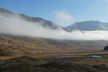
Morning at A'Chuil
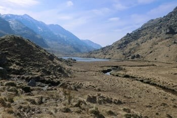
Approaching Lochan A’Mhaim

Bealach an Lagain Duibh

Leaving Glendessary Forest
Day Four
The following morning it looked like the weather was finally going to change for the worse as there were dark clouds moving in from the West. After the amazing weather we had experienced so far we couldn’t grumble! We had a decision to make between 2 possible routes; we could head for Inverie or Barrisdale. By this time we were both having a few problems with the trek taking its toll (what a pair of old crocks) so we decided it would be sensible to head for Inverie and return to see Barrisdale in the future. Hugging the beach, the tide had receded enough for me to easily walk round the headland to the salt flats at Carnoc.
We could see the bridge crossing the river and the ruins of the settlement of Carnoch in the distance but first had to cross the salt flats. Carnoch was once a thriving community on Loch Nevis until the clearances drove the crofters from their homes. There is no defined path across the flats you just have to pick your own way across whilst trying to avoid the deep marsh that is ready to swallow your leg unexpectedly. You never knew whether your foot would find firm ground or thigh deep bog. The gaiters worked brilliantly keeping most of the water out of my boots even when totally submerged! I only really got wet whilst attempting to clear a dubious part of the marsh that was deeper than expected. In throwing myself forward I ended up running through the bog which ended in a comedy fall and me sitting in the bog!
The bridge over the River Carnach has seen better days as it’s in a pretty dilapidated state with warning signed that it is unsafe. We took our chances like countless trekkers before us and crossed with no issues. Ahead of us was the climb up and over Mam Meadail which rose steeply from the valley floor. As we started to climb, black clouds closed in above us, the wind started to increase in ferocity and rain started to fall. It got increasingly heavy and turning to sleet as we gained altitude with the gale force wind driving the rain horizontally across our path. Our original plan had been to stop for lunch half way up and enjoy the views, a plan which got ditched in favour of getting the climb completed and finding shelter beyond the summit.
Carl made faster progress up the steep pass and I found him waiting with a hot cup of tea for me at the top. We huddled behind the only shelter available and sipped on hot drinks whilst devouring some snacks. There was no sign of the weather improving so once we had filled up on chocolate and trail mix we pressed on. With hindsight we should have stopped for lunch but given the conditions neither of us was much inclined to stay here for long.
The descent down from Mam Meadail into Glenn Meadail was for the most part pretty easy walking and would have been very enjoyable but for my aches, pains and the continual rain. It’s amazing how different this sort of landscape looks when the weather is poor. Gone were the clear blue skies to be replaced by dark clouds which poured rain on us for several hours without pausing. At the bottom of the pass the path levelled out before crossing a now very lively looking Alt Glenn Meadail which soon joined the Inverie River. We were now close to our final destination.
Once we crossed the Inverie River we could see the Brocket Monument which is only a couple of miles from Inverie itself. The monument was erected by Lord Brockett (a Nazi sympathiser who was generally reviled by the population of Knoydart). From here the final couple of miles were on hard packed vehicle tracks and in no time at all we were arriving at the bunkhouse. Typically as we arrived the rain finally decided to stop! Inverie Bunkhouse is owned by the Knoydart Foundation and profits are reinvested in projects for the good of the peninsula. We couldn’t fault it. Comfortable beds, powerful showers, a large lounge with a log burner and a decent drying room.
We had suspected that the pub was closed on a Wednesday which was confirmed on arrival so instead dinner was courtesy of the neighbouring Snack Shack. Here there was an honesty box in a shed containing a couple of large freezers packed with an awesome selection of frozen home cooked meals to microwave back at the bunkhouse. We both went for Chorizo bean casserole which was very tasty after a few days of freeze dried food. After this it was an early night as we were both knackered.

Looking back from Mam Meadail

Descent from Mam Meadail

Loch Nevis shoreline
Day Five
A walk into Inverie for brunch at the Knoydart Pottery and Tea Room was the first order of the day. The view from our table was amazing out across Loch Nevis. Soon a pot of tea and a bun crammed with bacon, egg and black pudding was sitting in front of me. After several days of freeze dried food it was so tasty. Bun number one was soon despatched and another ordered! I did pass on the wide selection of cakes so felt quite virtuous. The rest of the day was a mixture of exploring the village and chilling in front of the log burner in the large sitting room at the bunkhouse. The plan for the night was clear – a visit to the Old Forge Inn for dinner and a few beers. We had been looking forward to a pint or 2. We had read mixed reports about the Old Forge Inn and its eccentric owner but we had a great night. We had booked a table and were glad we did so as the pub soon filled up and some people were turned away for food. However we were lucky enough to enjoy a huge pot of fresh mussels harvest from the loch with chips and mayonnaise, the national dish of Belgium apparently (the landlord is Belgian), washed down with a few pints of beer.
We made sure not to have too many as we needed to catch the ferry in the morning to start our journey home.
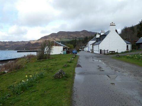
Inverie Village

Enjoying the scenery

Having a wander round

|
||
 |
||
|
Danny Pearson |
||
|
Dan is a keen distance walker who loves to geek over the latest gear. In the last few years, Dan has completed a couple of TGO Challenge crossings of Scotland (with another planned for 2024), GR221 in Mallorca, Dales High Route and Hadrian’s Wall plus countless other self-planned routes. A keen mountain biker but finds he doesn’t bounce so well these days when the inevitable happens. |
||
