Tour of the Matterhorn – Trip Report
Posted by Mark Richardson on Oct 01, 2021

In September 2021 I would have loved to travel to Nepal, I’ve backpacked in many places around the world but never been there – it’s a serious omission that I was determined to sort out, but that was before the pandemic. September 2021 then was allocated to a trip to Scotland.
In August a window of opportunity opened to visit Switzerland, my partner and I were both double jabbed and were therefore allowed to go, whoopee. It’s not Nepal, but Switzerland, and it does have another walk I’d had my eye on, the Tour of the Matterhorn. No matter that 18 th September was a bit late in the season we were getting a great opportunity to do some serious backpacking.
Days 1&2 – The Europaweg
Limited by holidays we had 8 days walking to complete a 9 day route, so we were looking at ways to make that possible, the Europaweg is, by all accounts, a stunning high level walk along the Mattertal valley to St Niklaus. Basically you gain height at the beginning of Day 1 and descend at the end of Day 2, although completing it in two days is a challenge.
With the weather forecast predicting heavy rain on Day 2 it made sense to cover as much of the high level route as possible on Day 1 and then possibly carry on past St Niklaus to claw some time back from the extra day we needed. We decided to take the Sunegga funicular lift to 2288m which would save perhaps 90minutes from Day 1 enabling our plan to work.
We left our hotel at 8.45 after a breakfast we didn’t deserve yet and walked the few minutes to the Sunegga lift, an astonishing underground funicular, it travels up inside the mountain at an amazing speed and pops out about half way up.
The weather was good and we were keen to get going, the views are stunning, especially of the Matterhorn, and we took many photos as we progressed along the path which undulates along the side of the valley until it reaches the small hamlet of Ottavan deep into a side valley above Tasch.
The Europaweg crosses the river and continues its spectacular traverse out of the side valley on the other side, the path is good with protected sections and tunnels where rockfalls are common. A gorge is crossed via a metal bridge and the path hugs the rocky slopes once more offering spectacular views of the peaks on the other side of the Mattertal (Zermatt valley).
After a bit of fiddly route finding we eventually reached the Charles Kuonen Suspension Bridge, which is the longest pedestrian suspension bridge in the world, its an impressive structure and replaces a shorter bridge at a lower level that was destroyed by rockfall in 2010 just 2 months after its opening. Without either bridge the Europaweg traveller had to endure a 3-4 hour detour.
After this crossing the Europahutte is not far away and we reached it at 3pm where we stopped for a brief lunch. Intending to walk for another three hours at least we headed off at a reasonable pace, the guidebook says there’s a good few hours of rough mountain terrain before anything meadowlike is reached, so we would have to make this sort of progress in order to have somewhere to camp.
After half an hour though we were approaching the remains of a bridge and the path was diverted downwards, the original trail continued clearly on the other side of the gully but the main path was signposted down. Here began the worst re-route of a path I’ve ever experienced, instead of a high mountain traverse with stunning views we were hiking down through forest in deep zig zags down very steep terrain helped across many sections by elaborate man-made ladders and platforms. It was an awful path which we followed for a few hours, always seeming to descend.
I became a bit concerned that there would be nowhere to camp as we had not seen any flat ground for hours and the route ahead looked to be more of the same. At 6.20pm we came to a path junction with a small patch of meadow next to some farm buildings, still in the forest but this small piece of dirt was open to the sky.
We asked permission and were allowed to camp on the only patch big enough to take a tent. Through breaks in the trees we could see the peaks that dominate the end of the valley in the direction of Zermatt. We rushed to get everything done, tent up, beds down, food cooked and eaten, quick wash and by that time the light was failing. The forecast was for heavy rain the following day but it didn’t start until 4am and the sky was crisp and clear as we went to bed. When the moon appeared it was so bright we were convinced someone had turned a light on.
We were woken by the rain, as forecast it was heavy, very heavy. We decided to have a cold breakfast as we didn’t want to fire up the stoves inside the porch of the tent. After packing our gear away and managing to flatten the inner tent without ever going outside, we were ready to strike camp. When the rain eased off slightly at about 8am we donned waterproofs and packed our camp away.
We followed the footpath which was challenging in places, wet and slippery, basically picking our way through a forest, up and down, but mainly down, which was a concern. Eventually we had descended almost to the valley floor, but we started to ascend again as we continued on towards Grachen.
After several other difficult sections, made worse by the rain, and about 2 hours since reaching the valley floor, we came to a sign saying ‘2hrs to Grachen’, which was essentially uphill from that point, but there was also a sign to St Niklaus, which we knew wasn’t far because we’d lost so much height compared with the day before.
The choice was to take the straightforward path to St Niklaus or walk 2 hours up to Grachen, then walk down to St Niklaus from there.
It was unclear how long the Grachen to St Niklaus would take. The path to Grachen was through forest and was a constructed path where there wasn’t a natural line, made possible with man-made walkways and steps etc – so not appealing.
The weather was still very poor as well, heavy rain and mist, so we made the choice to go straight to St Niklaus, which in the end took about an hour and a half, this picked up the alternative valley route between Zermatt and St Niklaus.
We arrived in St Niklaus about 1pm. We considered going on but the next section is a 5.5hour ascent up to the Augstbordpass, not so bad in good weather with great views but on this day it would be an unpleasant slog. It seemed much more sensible to wait and do the route tomorrow when the weather was better, it meant finishing early and losing all the time we’d gained but it seemed the best option. There’s no campsite option in St Niklaus so we booked into a hotel for the night.

Day 3 – The Augstbordpass
Our original weather forecast had said only one day of bad weather but the rain continued when we set off on Day 3. We took the 9.00am cable car to Jungi and started walking at 9.15, there were no views, the rain wasn’t heavy like the previous day but it was persistent with a heavy mist.
After 45 minutes on route to the pass there were bits of fresh snow on the ground and when it rained there was snow in the air, we continued upwards but unfortunately as we gained height the snow got deeper. My view was that if we got over the pass today then by the time we got to the glaciers in 3 or 4 days time the good weather that was promised over the next few days would have burned away this current snow covering, however looking at how much there was I was no longer sure.
At around 2420m we started losing the path in the snow, as the pass is 2894m there was nearly 500m still to climb, we were just at the start of the Trarore Ridge and we decide to turn back. The snow was getting deeper with altitude and we still had 400m or so to climb to reach the pass, we reasoned that it could become impassable. At the very least route finding would be a nightmare, no map will help you navigate the last sections to the pass, you have to be able to see the terrain in order to find the route up.
According to the guidebook the approach to the pass is pretty difficult if there’s snow on the ground, and we had plenty of that with very limited visibility, we did have crampons but using them would slow us down and we could end up still at altitude into the evening.
It made sense to turn back and abandon the route. The decision was validated at the station in St Niklaus as we met a Swiss guy who had been in Zinal, two days on the other side of the pass, doing the Haute route. Due to the dump of snow he abandoned any high level walking and got the bus from Zinal to St Niklaus, and was planning to do the valley route through to Zermatt.
We walked down the path into St Niklaus arriving at 2pm, we sourced an Airbnb apartment in Zermatt. We’d spent about 5 hours walking.

Day 4 – in Zermatt
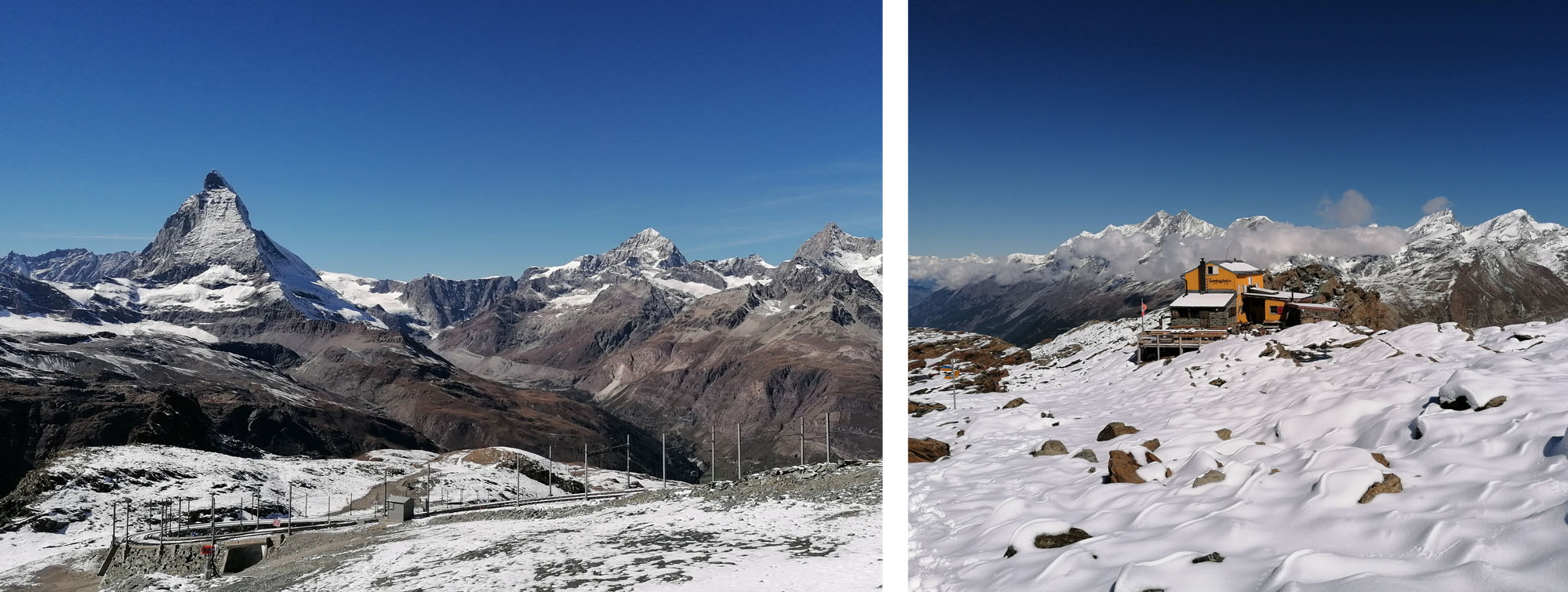
We decided to hike the ‘Glacier Trail’ from Trocknersteg, Jacqui had developed a knee injury so she took the cable car while I walked up. Part of the reason for choosing the Glacier Trail was that we could get a look at the end of the Tour of the Matterhorn – which crosses back into Switzerland from Italy, traverses the Theodule Glacier and passes Trocknersteg before the descent to Zermatt.
There was a lot of snow about but the weather had now changed, it was warm and sunny with clear blue skies, I imagined the new snowfall would be burned off in the next day or so. We completed the glacier walk and returned to the apartment. I decided to get back on the Tour of the Matterhorn route the following day in the hope that the snow would be clear enough for a crossing. We had lost two days from our eight but the last 3 days of the tour are key sections and I could complete these by getting a train then bus to Arolla.
Jacqui decided to opt out because of her injury, she could still do some spectacular walks around Zermatt, using the cable cars to gain height.
Day 5,6 & 7 – Arolla to Zermatt
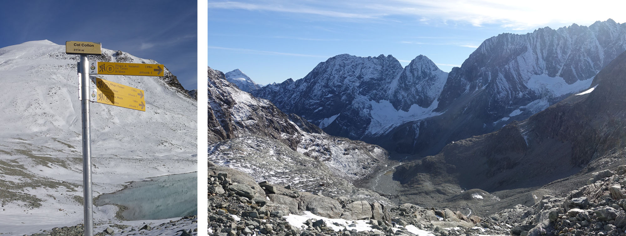
Got 2 trains and 2 buses from Zermatt – left at 8.37, Visp, Sion to Les Haudres and Arolla. Arrived 12 noon. A signpost in the centre of town said 5hrs to the Col Collon but the guidebook said it was 5.5 to 6. The former would give me an hour to find a camping spot on the other side of the col, the latter estimate would make for a nervous end to the day trying to find a good camping place before dark.
I decided to attempt to do the col today because I couldn’t see myself kicking my heels in Arolla for nine or ten hours, if the going was too slow I could decide to camp before the col rather than after it.

Day 5 – Col Collon
The first section is up a track which turns into a path, along the right hand side of the river, later cross over a bridge and turn right following signs for the Berthold hut. After 1hr 20mins from Arolla there’s a superb place to camp, opposite Bas Glacier d’Arolla. It’s a large flat grassy picnic area and I didn’t see any signs forbidding camping, if you reach Arolla at the end of a day and want somewhere good to camp wild then it’s worth the trek up to it.
Carry on, all steeply uphill but on a zig zag path – it’s a pleasure, with superb views of Mount Collon. Then you come to an aided section just after the shorter path for Plan de Bertol after which you go over a crest and the valley opens up, the glacier is at the far end to the left and you follow a path toward it through the moraine. After a while there seems to be any number of paths to the glacier, all marked with cairns. Eventually I reached the closest ‘nose’ of the glacier itself and climbed onto it.
I donned my crampons for the onward journey. There were a few routes worn into the snow and I followed whichever of these was heading in the right direction as a recently trodden path was the best way to avoid hidden crevasses. There are some signs of fissures in the glacier but also evidence that some people have crossed without crampons, crampons definitely made it easier but the general slope was shallow and there was no danger from falling down it.
Although the main glacier is not steep, once you get off it to the right there’s a steep climb up to the col. When I was there the slopes were a mix of snow and rocks so I took off my crampons. After the steep ascent the route plateaus out before a long incline to the col. The snow was pretty deep, trudging through was quite tiring but eventually I got there. It was five past five, 5 minutes short of the time indicated in Arolla. I had my cheese sandwich and some water for lunch.
On the other side of the col you can see a lake – guidebook says follow the French route – i.e. go up hill a bit to a signpost before following the path down to the refuge. Because there was a lot of snow cover you just couldn’t see that route whereas the Italian route was easy to see and seemed more direct, so I followed this almost to the refuge 45minutes later.
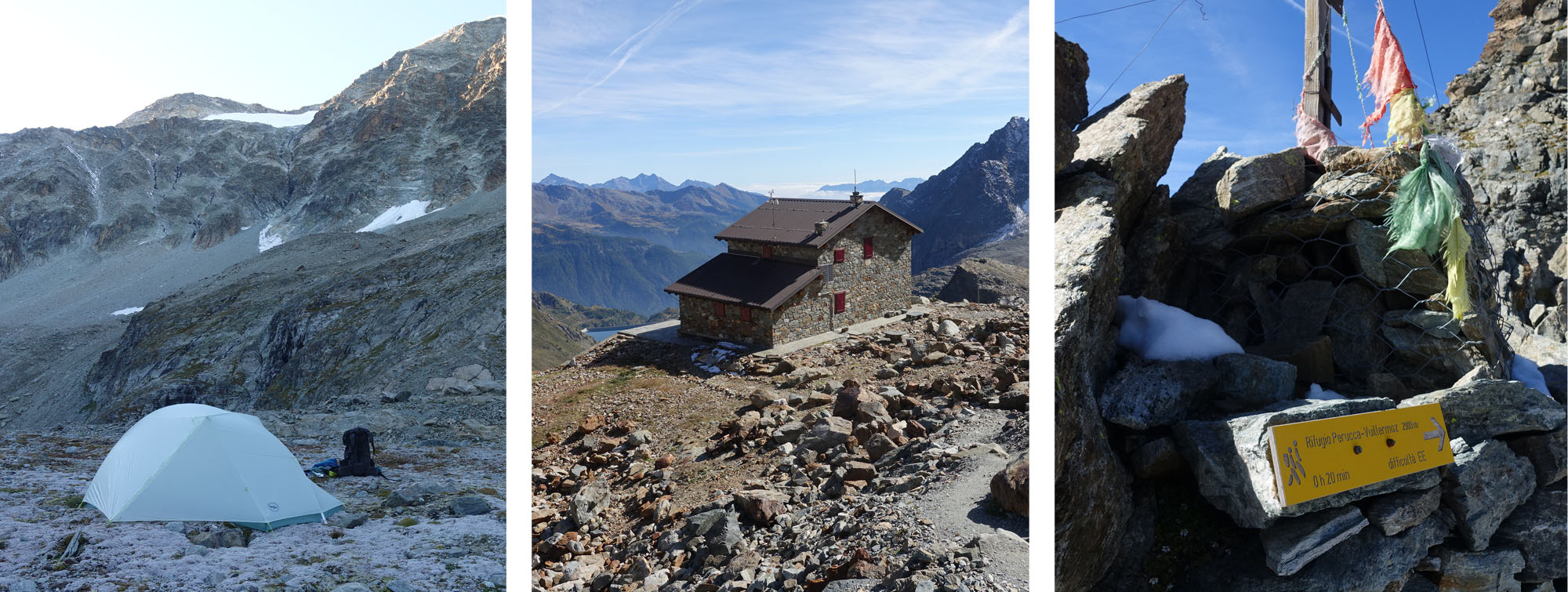
I took the little traverse mentioned in the guidebook which means you don’t have to go to the refuge, that took me down past another lake to a flat-ish area a few hundred metres below, by a melt water stream where I camped, at about ten past 6. The area was mainly rock but there was just enough ‘give’ for me to get the tent pegs in.
I found out the following day that if you go on past this there is a steep descent down to a lower plateau area which would have been a better place to camp because it’s on grass rather than rocks, after about 40 minutes. Having said that I enjoyed my high camp, as the refuge was closed for the season I had the area to myself, the altimeter on my watch read 2575m.
Day 6 – Colle di Valcournera
The following morning was another quite misty and overcast day, the descent to the farm Oren was straightforward enough on a good path, but beyond the farm I kept losing the path as it occasionally petered out and with low visibility it was difficult to regain it. I followed parts of paths downwards until I eventually reached a track, turning left I followed this past a barn to the edge of the Lago di Place Moulin where visibility improved and I could see the cluster of houses that was Prarayer in the distance.
I continued through the village turning right, descending through woods and crossing the lake inlet, then rising steeply to gain the higher side-valley floor which you follow for an hour or so as it gently gains altitude. It’s a pleasant walk, the early morning mist had evaporated and I could see the previous days route across the main valley, eventually, after about an hour and a half you reach a large boulder which signposts the way to Colle di Valcournera, its virtually a ninety degree left turn that takes you directly up the steep valley side.
It's an absolutely stunning path, nearly all of it steep uphill. There’s a short section about 30mins where you follow the valley at an easy incline, but then its steep ascent followed by very steep ascent. 2.5 hrs. Very exposed for a lot of it with supported scrambles on the most difficult sections.
Eventually you break out and can see the col ahead, but the terrain looks uninviting, small loose rocks form a steep slope with the col at the top of it, it’s a monumental slog.
I was very glad to reach the col at a quarter past 2, fifteen minutes later than the sign had predicted at Prarayer, it had taken 3 hours 45 minutes. I ate my lunch on the Prarayer side of the col before venturing over for a look.
I got a shock because the guidebook says to go right from the col then straight down, but that route was very steep with a smattering of snow, and I struggled to see either a path or any way down the obvious cliff. There were tracks in the snow that roughly fitted the description but they started out on the steep slope and I couldn’t tell if they were people or animal. In any case they disappeared over the cliff.
I’ve been walking long enough to know that paths aren’t always obvious and they can thread through difficult terrain with ease, however this was definitely different, even the relatively easy approach to the steep descent looked risky and I decided I was not prepared to tackle it even if it meant turning back to Prarayer.
On the other side of the col though a sign for the refugio points to the left, the opposite direction to the guidebook. Clearly I was going to take this route and packed my rucksack. Even then the route was not easy, it had been constructed through steep rocky terrain and there were lots of fixed ropes to hang onto as you negotiated the steepest bits and even iron walkways where the terrain just isn’t suitable for walking. I picked my way down, taking ages until I got to the more gentle slopes further down.
As I hiked towards the Refugio Perucca-Vuillermoz I constantly stopped to look at the cliffs down which the guidebook suggested I should have gone, there was definitely no way down them, I shudder to think what would have happened if I’d attempted the suggested route.
After 90mins from col, I came down beyond Refugio Perucca-Vuillermoz and Manettis bivouac, then you come to an area that would be perfect for a wild camp, but it’s a bit too early for me, a bit too far from my goal. I continued on through pasture until I could see the last pass before Breuil Cervinia, Finestra di Cignana.
I reached this last pass at 5.05. My only gripe with Cicerone guides is that they often don’t cater for backpackers, and it was here that some knowledge of places to camp and/or water sources would have been useful. I wanted to carry on a bit longer but the terrain on the other side of the col looked steep, lacking in water and unsuitable for camping, if I carried on I would have to keep going until I found a suitable place. The guidebook route describes following the path over the col then heading down through larch forest to the valley floor and a village called Perreres at the main road.
I decided to carry on over the col but if there was no place to camp soon I would turn back and camp on the pasture before the col, the last thing I wanted was to end up at a low level looking for a place to camp by a road. I travelled for 20 minutes before turning back as the terrain was still very steep and I had seen no water at all.
I returned to the col and camped just below it, there was no immediate water there was a gully with a stream just a ten minute walk away where I obtained enough water for the night.
As you will see, had I gone further on the path over the col there were places to camp, and they were high on the mountainside, amid great scenery, I had made the wrong choice on this occasion. I setup camp around 6pm.
Day 7 - Breuil Cervinia, Theodulpass and Zermatt
My morning routine was getting faster, I got up at 6.40 and left camp at 7.45 and headed over the Finestra di Cignana five minutes later. After an hour I found the first suitable wild camping spot with water, had I kept going the previous day I would have been fine, and have an hour less to do today.
The path is a fine one, staying high on the side of the valley and relatively quickly has great views of the Matterhorn (Italian side) and the village of Breuil Cervinia at the head of the valley. The weather was good and the walking excellent.
Soon I was at odds with the guidebook again which, half way along the balcony path, suggested heading down to Perreres and getting the bus to Breuil Cervinia from there. At the junction that would take me down to Perreres there was also a sign for Breuil Cervinia that continued along the balcony path, and it claimed it was only 1hr and 20 minutes.
I decided to stick with the balcony path for obvious reasons, the Breuil Cervinia route said 107 on the signpost but as it transpired I never saw that number again despite staying on the well worn path. I was following 65 in the main, which was contouring on the balcony path along the valley, I could see Breuil Cervinia all the time so there wasn’t really an issue.
Route 65 continues until you are almost above the village then there’s a signpost for a new route, number 11. There are also some great wild camping spots near to where the route heads down for the village. Route 11 was frustrating – one sign said Breuil Cervinia was 30 minutes away, I walked along it for ten, then it said Breuil Cervinia was 35 minutes away!
I finally reached the centre of the village at 11.00am, just over three hours from the Finestra di Cignana. It was deserted and I struggled to find the route out to Plan Maison, but eventually did and climbed the steep path to the cable car station. I filtered some water here and had a big lunch.
My intention was to climb to the Theodulpass and cross the glacier to the Trocknersteg cable car station and take it down into Zermatt, after all I had climbed up to the station four days earlier when I was checking out the route and snow conditions.
The route to Theodulpass is easy to navigate but dreary and a bit of a slog, you climb up ski pistes for around two hours and I reached the mountain hut just before 3pm. To get to the pass you must go down a snow slope to the rocky col, here I put my crampons on. The route from the col down to the glacier is tricky, the snow was deep and I needed crampons, once on the glacier though you basically follow the ski piste. There are certainly crevasses on the right hand section of the glacier but on the ski piste I could see little danger. Luckily it was quiet and I was only overtaken by a couple of skiers, and I met a mountain runner heading in the opposite direction with just running shoes for traction.
As I was heading for the cable car and not heading down on foot I walked to the end of the piste, the book mentions it being fairly grotty here and that’s what I found. Once off the snow it’s a sea of mud for about 50 yards, my boots were claggy and I was very happy to see a boot cleaner at the entrance to the cable car. The traverse of the glacier had taken an hour and fifteen minutes, I finished at a quarter past 4.

Reflection
The last three days had been wonderful walking, combined with the first day it had been well worth the trip, however I was left a little disappointed with some elements, the permanent changes to the Europaweg change the character of this route completely and while I understand it is for good reasons the alternative route that has been constructed is awful.
I was also irritated by the guidebook, which has never happened before but I felt let down in some instances:
- The suggested route off Colle di Valcournera is impossible for me to fathom, perhaps there used to be a route down but its since been broken resulting in the alternate route I took. I took a photograph as I descended, if you look closely you can see the tracks in the snow heading across the slope, you can also see the sheer cliffs below it.
- The lack of any information that would be useful to campers was a big omission, the Cicerone guides are not great at this but you can usually glean some information about the possibilities for camping on the route.
- Also I can’t understand coming off the balcony path to go down to Perreres, then suggesting hikers get the bus to Brueil Cervinia, the continuation of the balcony path is a great route. Even if its judged to be too far in one stage it should at least be suggested as an alternative.
I was also disappointed in our not completing the full route as we intended to do, however I am still content that we made the right decision in not tackling the Augstbordpass after the snowfall.
Tour of the Matterhorn – Getting there and back
Tour of the Matterhorn – Costs

|
||
 |
||
|
Mark Richardson |
||
|
Mark was the founder of Ultralight Outdoor Gear back in 2006 and has completed long distance backpacking routes in some of the remotest parts of the world. His favourite hikes have been Torres del Paine (full circuit), the John Muir trail and the Markha Valley trail (Ladakh, India). Although semi-retired Mark has not lost any enthusiasm for minimalist backpacking and is tackling Scotland’s Munros choosing multi-day backpacking routes over the more usual guide book excursions. |
||